

El Salvador: Adventure, Culture and Whale Shark Expedition
Volcanoes, coffee towns, Pacific surf and a day offshore looking for whale sharks.
From £2,595
£519 deposit to reserve, payment plans available

Eight days in the North Atlantic between Scotland and Iceland: three days of sea kayaking beneath the basalt cliffs of Kalsoy, the ridge walk to Kallur Lighthouse, and a guided day among a quarter of a million seabirds on Mykines.
The Faroe Islands are eighteen pieces of basalt dropped into the North Atlantic roughly halfway between Shetland and Iceland, and almost nobody goes there. Mountains rise straight out of the sea to seven and eight hundred metres. Waterfalls leave the cliff tops and never reach a river. Villages of eleven or thirteen people sit on green ledges at the head of fjords, roofs turfed, everything painted against the weather.
This expedition takes the islands from the water and from the ridge. We begin on Vagar, where a single-lane tunnel leads to Gasadalur and the waterfall at Mulafossur pours off the cliff into the Atlantic. Then we go north to Klaksvik, put kayaks in the fjord and spend three days paddling the coast of Kalsoy, the island the Faroese call the flute, camping beside the sea with puffins and guillemots overhead and no darkness to speak of.
The second half is on foot. The grassy ridge from Trollanes out to Kallur Lighthouse, with the cliffs dropping away on both sides. Tinganes in Torshavn, where the Faroese parliament has met since before anyone thought to write down when it started. The Viking farmstead at Kirkjubour, lived in by the same family since 1550. And a guided day on Mykines, standing above the largest puffin colony in the islands while gannets work the water below. Twelve guests, eight days, nearly twenty hours of daylight a day.
Atlantic Airways fly direct from Edinburgh to Vagar in about an hour and twenty five minutes, and the landing is part of the trip: the runway sits in a narrow valley two kilometres east of Sorvagur, with the mountains close on both sides. Your leader meets the group in arrivals.
We do not waste the afternoon. A single-lane tunnel of roughly 1.4 kilometres runs through the mountain to Gasadalur, a village of about a dozen people that had no road at all until the mid 2000s. Before the tunnel, the postman walked over a pass of more than four hundred metres with the mail on his back, three times a week. Five minutes from the car park is the viewpoint over Mulafossur, where the village stream leaves the cliff and drops into the open Atlantic with nothing underneath it.
On the way back we stop at Bour, turf roofs and black timber above the fjord, looking west to the silhouette of Tindholmur with its five peaks and, beyond it, the sea stacks of Drangarnir. In the evening we eat together and run the full expedition briefing: how the week works, the kayaking plan, the kit check and the weather.
After breakfast we drive north, and the drive is a small event in itself. The Vagatunnilin runs 4.9 kilometres and 105 metres below the sea to get us off Vagar. The Eysturoyartunnilin is 11.2 kilometres long and contains the world's first undersea roundabout, 73 metres down, lit by an eighty metre steel and light sculpture by the Faroese artist Trondur Patursson. Then the Nordoyatunnilin, 6.2 kilometres from Leirvik under the sound to Klaksvik.
Klaksvik is the second town in the Faroes, about five thousand people wrapped around a fishing harbour with mountains standing over it on every side. This is where the kayaking starts. Our local guides run the safety brief, fit everyone to a boat, and we launch into the sound and paddle north towards Kalsoy, the long thin island the Faroese nicknamed the flute because it is drilled through with tunnels.
We land near Sydradalur and make camp beside the sea. It is mid June, so the light does not go: dinner is eaten at ten at night in what still looks like early evening, with fulmars going past at eye level and the water flat and grey-green in the sound.
The best day on the water. We work north along the Kalsoy coast, and the scale takes a while to adjust to: basalt cliffs going up out of the sea in horizontal layers like stacked bookshelves, streams coming off the top of them and blowing back up in the wind before they land. We nose into sea caves and rocky inlets where the swell allows, and land where there is somewhere to land, to stretch legs and eat something hot.
This is seabird country at the right time of year. Puffins are ashore from mid May until the end of August and mid June is the heart of it, so expect them on the grassy ledges above and rafted on the water in front of the boats. Guillemots and razorbills come past low and fast, fulmars hang on the updraught off the cliff and barely move a wing, and kittiwakes make the noise.
We camp again on a headland. In the third week of June there are close to twenty hours of daylight and no real darkness at all, so the evening simply goes on: the light turns from white to gold to a long, slow, pink dusk that has not finished by the time everyone gives up and goes to bed.
The final kayaking day, and often the calmest. We paddle south through the sound towards Klaksvik with the mountains reflected in the water on a still morning. Harbour seals are common along the fjord edges and will follow the boats at a distance, and white-beaked and white-sided dolphins are seen in these waters, though never on demand.
We land at Klaksvik in the afternoon, hand back the boats and the kit, and check into the hotel. After three days on the water and two nights under canvas, a hot shower and a bed with sheets on it lands extremely well. In the evening we eat together in town and mark the end of the kayaking properly.
The twenty minute ferry from Klaksvik to Sydradalur takes the little M/F Sam across the sound, and then we drive the length of Kalsoy on a road that is more tunnel than road: four unlit single-lane bores with passing bays, the longest of them the 2,250 metre Trollanestunnilin, cold and dripping and entirely dark. We pass Mikladalur, where the bronze Kopakonan, the seal woman of the old story, stands in the sea below the village.
From Trollanes the walk begins. It is roughly 2.4 kilometres each way with about two hundred metres of ascent, on grass and sheep tracks rather than a made path, and it takes most people forty to forty five minutes to reach the lighthouse. It is not a hard walk. It is, however, an exposed one: the ground falls away steeply on both sides near the top and there is nothing between you and the sea. From the lighthouse you look east across Kunoy, Bordoy and Vidoy, and north to nothing but water.
In the afternoon we drive south to Torshavn, which at fourteen thousand people is a capital city with the footprint of a market town. We are here for three nights, so unpack properly.
A day off the water and off the hill. We start in Torshavn on Tinganes, the low rock peninsula between the two harbours where the Ting has met since the Viking age. The Faroese parliament, the Logting, is already described as long established when it turns up in the Faereyinga saga in the mid 900s, which puts it among the oldest surviving assemblies anywhere. The government still works out of the same red timber buildings with grass on their roofs; Munkastovan and Leigubudin survived the fire of 1673 and are the oldest of them.
After lunch we drive twenty minutes south-west to Kirkjubour, which was the bishop's seat and the cultural centre of the islands for four hundred years. Three things stand within a hundred metres of each other. The Magnus Cathedral, begun around 1300 and the largest medieval building in the Faroes, now roofless. St Olav's Church, built before 1200 and the oldest church in the country. And Kirkjubourgardur, whose smoke room dates to the 11th century and which is very probably one of the oldest inhabited wooden houses in the world: the Patursson family have lived in it since 1550 and the seventeenth generation is there now.
We eat together in Torshavn in the evening. The town punches far above its size for food, and this is the night to try something you would not order at home.
Mykines is the far west of the archipelago and the best seabird island in the country. The ferry M/F Josup runs from Sorvagur and takes about forty five minutes; there are three sailings a day through the summer season and boarding involves a small step across, which is worth knowing in advance. The island holds nine permanent residents and something in the order of 250,000 breeding seabirds across fifteen species.
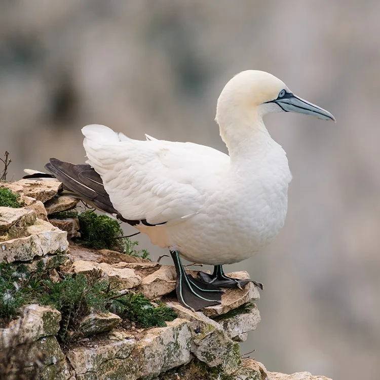
The whole outfield is protected and can only be walked with a licensed Faroese guide, with a cap of two hundred visitors a day and access between 10:00 and 17:00. We walk out from the village along the cliff edge to the viewpoint at a Rogvu, which looks down over the largest puffin colony in the islands, roughly 125,000 pairs of them. In mid June they are ashore and busy, standing about outside their burrows in a way that makes it very hard to leave. Kittiwakes and fulmars work the cliffs below, and out on Mykinesholmur beyond the footbridge is the only northern gannet colony in the Faroe Islands.
One honest note. The path across the footbridge to Mykinesholmur and the lighthouse is closed through the summer months to protect the recovering puffin population, and the ground beyond a Rogvu is also shut because of landslide risk. You will see the bridge and the holm; you will not walk to them in June. What you get instead is several hours above one of the great seabird colonies of the North Atlantic. We are back on the afternoon boat and eat our farewell dinner in Torshavn.
We check out and drive north-west to Saksun, which is eleven people, a working sheep farm and a church of 1858 that was taken down in Tjornuvik and carried over the mountains piece by piece. It sits in a natural amphitheatre of cliffs at the head of a valley, and the sight of it stops conversation in the vehicle.
Below the village is Pollurin, which used to be a natural harbour until a storm filled its entrance with sand. It is now a tidal lagoon: full and mirror-flat at high water, and at low tide a wide beach you can walk out along, around the headland, to where it opens to the sea. We go only if the tide allows, we keep to the marked paths, and we remember that all of this is somebody's farm.
There is time for a coffee looking down the valley before we drive back to Vagar, about an hour away, for the flight to Edinburgh. Eight days, three of them on the water, one of the best seabird colonies in the North Atlantic, and a set of photographs that nobody at home will quite believe.
It is graded Easy, the first of our four grades. That is 8 days of it, so being ready matters more than being fast. If you are unsure whether it suits you, talk to us before you book rather than after: we would far rather move you to the right adventure than watch you struggle on the wrong one.
Every trip runs with qualified leaders, a risk assessment written for the route, emergency procedures and communications planned before departure, and local support on the ground. Travel insurance covering your chosen activities is a condition of booking.
The Faroe Islands are a self-governing part of the Kingdom of Denmark, but they are not in the European Union and not in the Schengen area. British citizens need no visa for tourism. This matters most if you hold a passport that normally requires a visa for Europe: a Schengen visa is not valid for the Faroe Islands and a specific Faroese permission is needed, applied for through the Danish authorities well in advance. If that applies to you, tell us at booking and we will help. Your passport should be valid for the duration of the trip; we recommend six months' validity beyond your return date as a matter of habit.
International flights are not included. The trip starts and finishes at Vagar Airport (FAE), which sits in a valley two kilometres east of Sorvagur and about 45 minutes from Torshavn. Atlantic Airways fly direct from Edinburgh, taking around an hour and twenty five minutes, and the service runs twice a week from March to December. There are also connections via Copenhagen. Because the direct service is infrequent, book early and add your flight numbers to your guest portal as soon as you have them so we can plan the arrival meet and the departure transfer. Let us know early if you want to add nights at either end, which is easy to arrange and often worth doing.
June is one of the best months here and it is still not warm. Expect daytime highs of around 10 to 12 degrees Celsius and overnight lows of 6 to 8, with the sea at 8 to 9 degrees. It is cloudy more often than not, showers are frequent but usually short, and fog is common in the mornings and on the crossings. The wind is the thing people underestimate: it is close to constant, and the official tourist board line is that weather can differ dramatically between islands or even between two sides of the same hill. The compensation is light. Around the solstice there are close to twenty hours of daylight and no true darkness at all.
This is an active trip at a relaxed pace rather than a hard one. Three days are spent sea kayaking, in stable boats on sheltered water with local guides alongside, and no previous experience is needed. Two of those nights are camping. The walking is short: the Kallur Lighthouse route is about 2.4 kilometres each way with roughly 200 metres of ascent, and the Mykines walk is a guided two to three hours. What the trip does ask for is tolerance of cold, wind and wet, three days in a row on the water, and comfort near unfenced cliff edges. If you walk regularly and are happy in a boat, you will be fine.
There is almost no fencing anywhere in the Faroe Islands, including at the top of a six hundred metre cliff. At Kallur the ground falls away steeply on both sides near the lighthouse. The narrow ridge beyond the lighthouse, which is the photograph everybody has seen, is genuinely exposed and we treat it as optional and conditions dependent: in fog or strong wind we do not go, and anyone who would rather not is very welcome to wait at the lighthouse with a flask. Nobody is talked into anything. If you know that heights bother you, add a note to your guest portal when you book so we can plan the day around you.
You do not need to be a strong swimmer and you do not need kayaking experience. We use stable sea kayaks, everyone wears a buoyancy aid at all times on the water, and qualified local Faroese guides who know the tides paddle with the group throughout. All equipment is provided, including a wetsuit or drysuit, cag, spraydeck and boots. The real challenge is the temperature rather than the swimming: the sea is 8 to 9 degrees in June and the kit does most of that work for you. What we do ask for is honesty. Add a note to your guest portal when you book on how confident you are in open water, so we can pair you sensibly.
Two nights of this trip are spent under canvas on Kalsoy, and it is one of the best parts of the week. Two person tents, sleeping mats and all group cooking and shelter kit are provided and carried by the team; you bring a sleeping bag and a liner. There are no facilities: this is a proper expedition camp beside the sea, with a cook shelter and a toilet arrangement your leader will explain. All camping in the Faroe Islands is by arrangement with the landowner, which we hold in advance for every departure. In mid June there is no real darkness, so bring an eye mask if you sleep lightly.
Mykines is the highlight for most guests and it comes with conditions we would rather you knew in advance. The whole outfield is protected: it can only be walked with a licensed Faroese guide, there is a limit of two hundred visitors a day, and access runs from 10:00 to 17:00. The path across the footbridge to Mykinesholmur and the lighthouse is closed through the summer to protect the recovering puffin colony, and the ground beyond the a Rogvu viewpoint is closed for landslide risk, so we do not walk to the lighthouse in June. What we do get is several hours above the largest puffin colony in the Faroes. The ferry is also entirely weather dependent and can be cancelled, so we carry an alternative plan for the day.
Comprehensive travel insurance is a condition of joining this expedition and must cover medical treatment, emergency evacuation and repatriation, and must specifically include sea kayaking and camping. Read the activity wording rather than assuming. No vaccinations are required. Important for British guests: a UK GHIC or EHIC card is not valid in the Faroe Islands, but a reciprocal agreement between the UK and the Faroes gives British nationals equivalent treatment, so carry the card and your passport as proof of nationality. The emergency number is 112, and for out of hours medical advice call 1870. There are hospitals in Torshavn and Klaksvik. The tap water is excellent.
The currency is the Danish krone, alongside the Faroese krona which has the same value. Cards are accepted almost everywhere, mainly Visa and Mastercard, but American Express usually is not, and cash machines are common in towns, so there is no need to bring cash from home. Power is European two-pin, so UK guests need an adaptor. Mobile coverage is 4G and 5G nationwide in theory, though it is patchy in the Kalsoy tunnels and on the crossings. Note that UK and EU roaming allowances generally do not include the Faroe Islands, because they are outside the EU, so check your tariff before you travel or plan to use hotel wifi.
Faroese food is better than its reputation and built on what the islands actually produce: lamb, seabird, fish landed that morning, and the dried and fermented specialities that are a matter of national pride. Torshavn has a genuinely good restaurant scene for a town of fourteen thousand people. Hotels serve a buffet breakfast, and camp meals are cooked by the team and are hot, plentiful and unpretentious. Vegetarian is straightforward if you add it to your guest portal. Vegan, gluten free and any serious allergy must be added to your guest portal when you book so that we can brief the hotels, the kayak operator and the camp kitchen in advance. Please add it even if you think it is minor.
The Faroes are a photographer's destination and this itinerary is built around the two things that matter: light and access. Mid June gives close to twenty hours of it, with a golden hour that lasts most of the evening. Bring a wide lens for the landscapes and something in the 200 to 400mm range for the seabirds. Everything that goes on the water needs a dry bag or a waterproof housing, and salt spray is unforgiving, so bring lens cloths and a blower. Please always ask before photographing people or their houses: several of the villages we visit have a dozen residents and they live there.
Secure your place with a deposit today, then spread the balance interest free. How payment plans work
Not sure yet?
Talk it through with someone who has been there. Call 0191 903 9936 or send us a question.
| Dates | Availability | Price | Book |
|---|---|---|---|
| 10 - 17 June 2028 | Places available12 places left | £2,495 | Book this date |


Volcanoes, coffee towns, Pacific surf and a day offshore looking for whale sharks.
From £2,595
£519 deposit to reserve, payment plans available
Camels carry, horses ferry: thirteen days in Mongolia's remote northwest.
From £2,995
£599 deposit to reserve, payment plans available
Lion and rhino, desert elephants, seals in the surf and the highest dunes on earth.
From £4,795
£959 deposit to reserve, payment plans available

